Learn more
Brief geographical information about Buitenveldert
Maps 1 and 2 show the area south of Amsterdam in 1849 and 1950. On the 1849 map you can see tavern ‘Het Kalfje’ south of the city of Amsterdam along the river Amstel. In 1849 it is the only building in the area that is now Buitenveldert. Comparing both maps you can see that during the hundred years between 1850 and 1950, the city of Amsterdam has grown considerably and many lakes such as Bijlmermeer and Haarlemmermeer have been drained. Map 2 shows the Bosbaan, but Buitenveldert has not been developed. Also the Amsterdamse Bos is older than Buitenveldert. East of the Bosbaan is the Binnendijkse Buitenveldertsche Polder. This was an area with farms, market gardens, meadows and fields. In the sixties Buitenveldert was built here as a garden city. Since 1955 the area has been raised with sand and piles were driven for a solid foundation. Then houses and flats were built. The first residents came around 1960. They lived in flats in the eastern part of Buitenveldert, see map3. Most buildings are from the sixties, see map 4. Buitenveldert now has more than 20.000 inhabitants.
The development of Buitenveldert from polder to city district between 1815 and 2021 can be clearly seen:
- on maps in topo time travel, see topotijdreis.nl
- in photos in the image bank of the Amsterdam municipal archive, see archief.amsterdam
The main streets in Buitenveldert are named after bailiffs (administrators) of Amstelland and Waterland. Smaller streets are named after provinces and castles. Around a street named after a province are streets named after castles in that province.
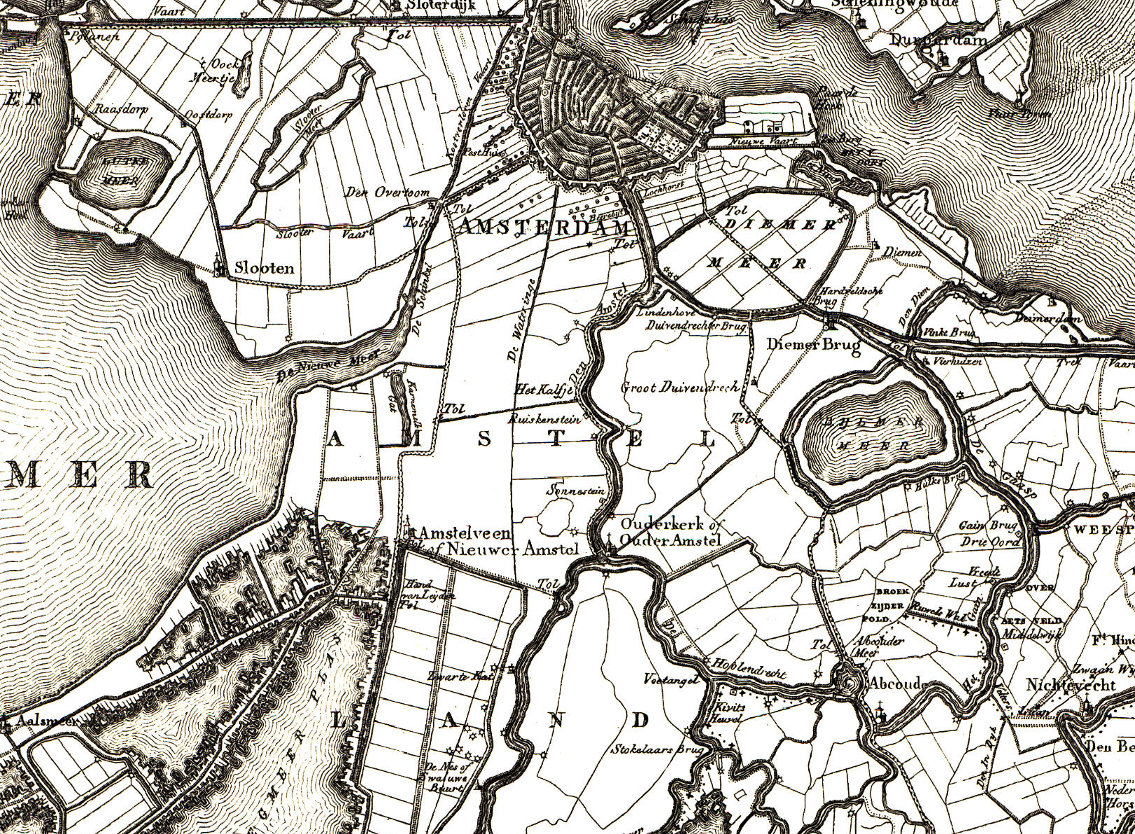 Map 1: The area south of Amsterdam in 1849 (Source: Kadaster Topotijdreis ‘CC-BY Kadaster 1849’)
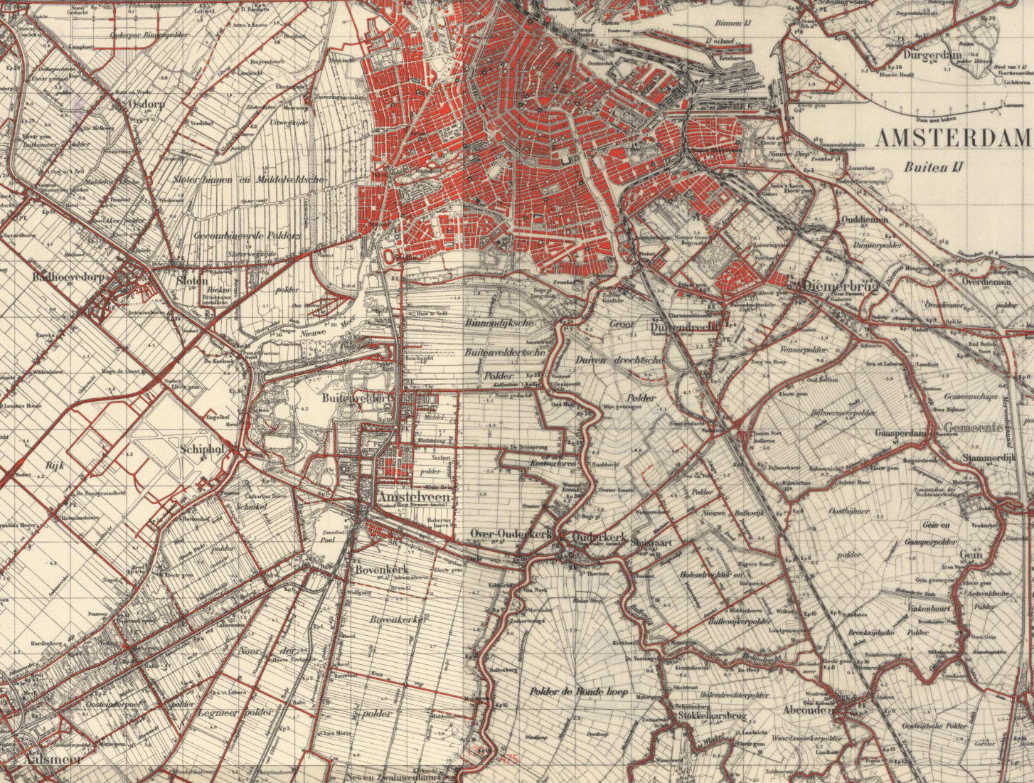 Map 2: The area south of Amsterdam in 1950 (Source: Kadaster Topotijdreis ‘CC-BY Kadaster 1950’)
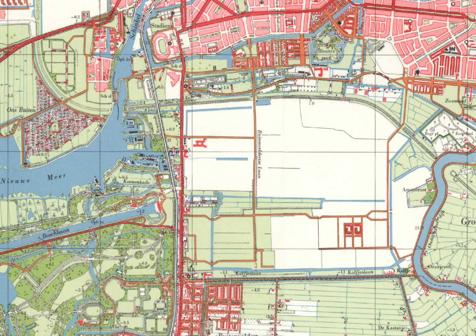 Map 3: The area south of Amsterdam in 1961 (Source: Kadaster Topotijdreis ‘CC-BY Kadaster 1961’)
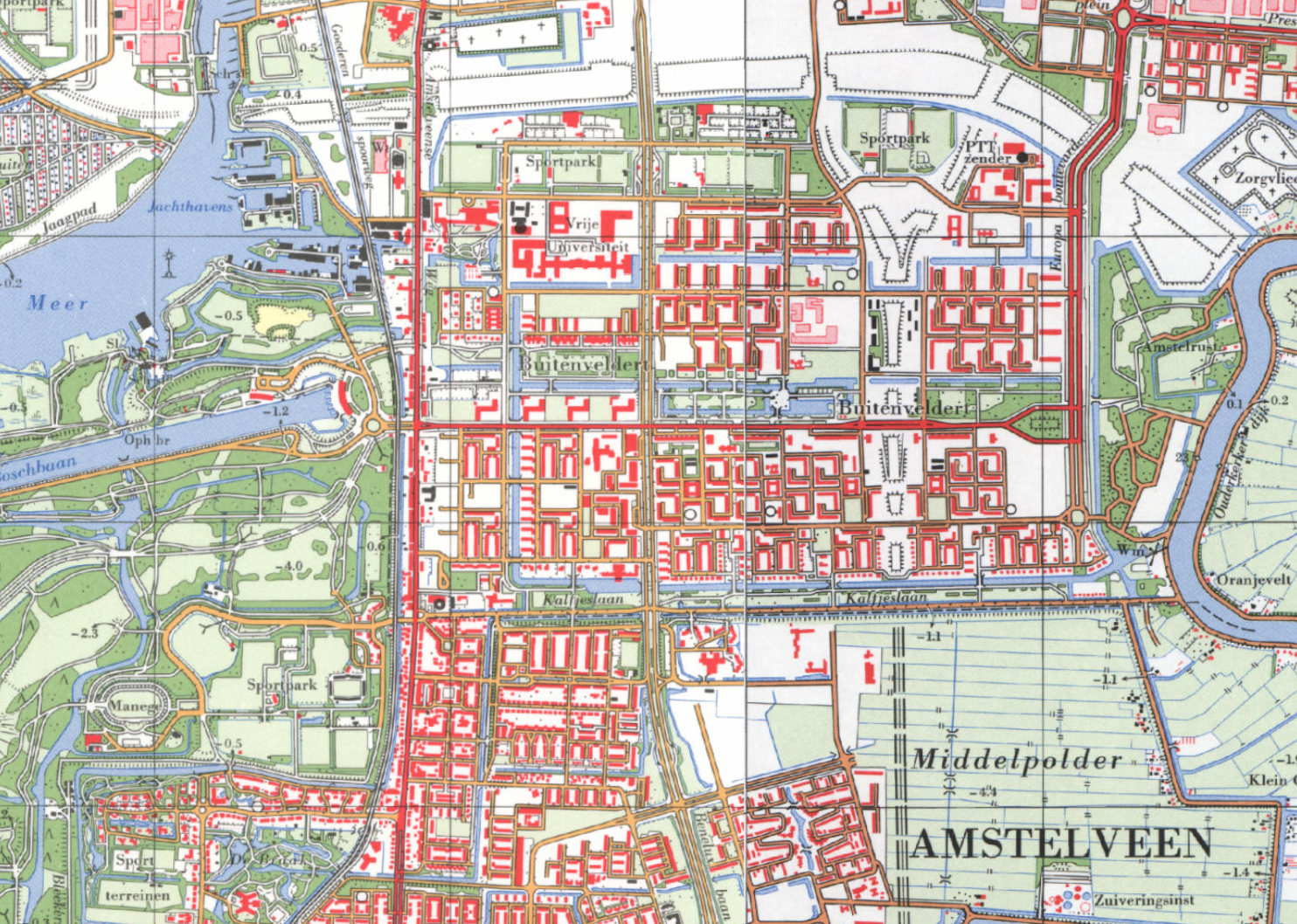 Map 4: The area south of Amsterdam in 1969 (Source: Kadaster Topotijdreis ‘CC-BY Kadaster 1969’)
‘The development of Buitenveldert 1958 – 1998 - 2008’ is a book written by Hendriekje Bosma, Liseth van Dongen and Helene Fentener van Vlissingen and published by VU University Amsterdam in 1998. Most of the following information comes from this book:
- In 1961, the plan was to build a district in Buitenveldert with 9,000 homes for 30,000 residents, including workers’ homes, ‘at a relatively high level’.
- Buitenveldert is characterized by repetitive structures of terraced houses, flats and villas:
- low flats of 3 floors without a lift with garages or storage rooms in the basement, as can be seen along Bovigne and Wildenborch and the A.J. Ernststraat;
- high-rise flats with offices, shops or garages in the basement along main roads such as Van Nijenrodeweg, De Boelelaan and Europaboulevard.
- single-family homes in repeating structures of terraced houses as can be seen in Gunterstein and Nederhoven.
- some strips with bungalows and villas as can be seen along Weldam, Ouborg and De Cuserstraat.
- Many houses are ‘sun through’ houses. Many flats are arranged in semi-open residential blocks. Schools, playgrounds and green areas are located between the residential blocks that are not built too close together. All homes that are not located on the ground floor have a balcony. Urban planner Jacoba Mulder had a great eye for the living comfort of the residents of Buitenveldert.
- Buitenveldert has a specific structure from low to high from south to north. At Kalfjeslaan there are low bungalows and single-family houses, then the low flats along and behind Van Boshuizenstraat and then the high flats at Van Nijenrodeweg.
- In addition to the main shopping center Gelderlandplein, various neighborhood shopping centers have been built throughout Buitenveldert, such as along Buitenveldertselaan, A.J. Ernststraat and Kastelenstraat.
- Gijsbrecht van Aemstelpark fits in well with the design of the residential buildings in Buitenveldert: sober and functional with many straight lines. The principles of the pre-war ‘Building New’ are clearly recognisable.
- The three parks (Amsterdamse Bos, Gijsbrecht van Amstelpark and Amstelpark) and the planting of trees and shrubs along the roads give Buitenveldert the allure of a garden city.
- There are three main north-south routes through Buitenveldert: Amstelveenseweg, Buitenveldertselaan and Europaboulevard. Because Rotterdamseweg was never built and Europaboulevard was not extended to Amstelveen, there is a lot of traffic at the west side on Amstelveenseweg and Buitenveldertselaan. There are three main east-west routes through Buitenveldert: De Boelelaan, Van Nijenrodeweg and Van Boshuizenstraat.
- The growth of the Zuidas has connected three locations on the north side of Buitenveldert: Vrije Universiteit, Zuid/WTC station and the area around RAI station. In the Zuidas master plan from 1998, the area is designated as an office location with housing and other facilities next to it. Where there used to be meadows and sports fields after 1960, the impressive high-rise buildings of Zuidas arose. It is a unique and therefore sought-after and expensive location conveniently located in relation to Schiphol Airport and the center of Amsterdam. The pressure here on the environment is enormous. This is due to the intensive use of land: tall offices and residential blocks, and the highway (A10) and railway that run right through Zuidas.
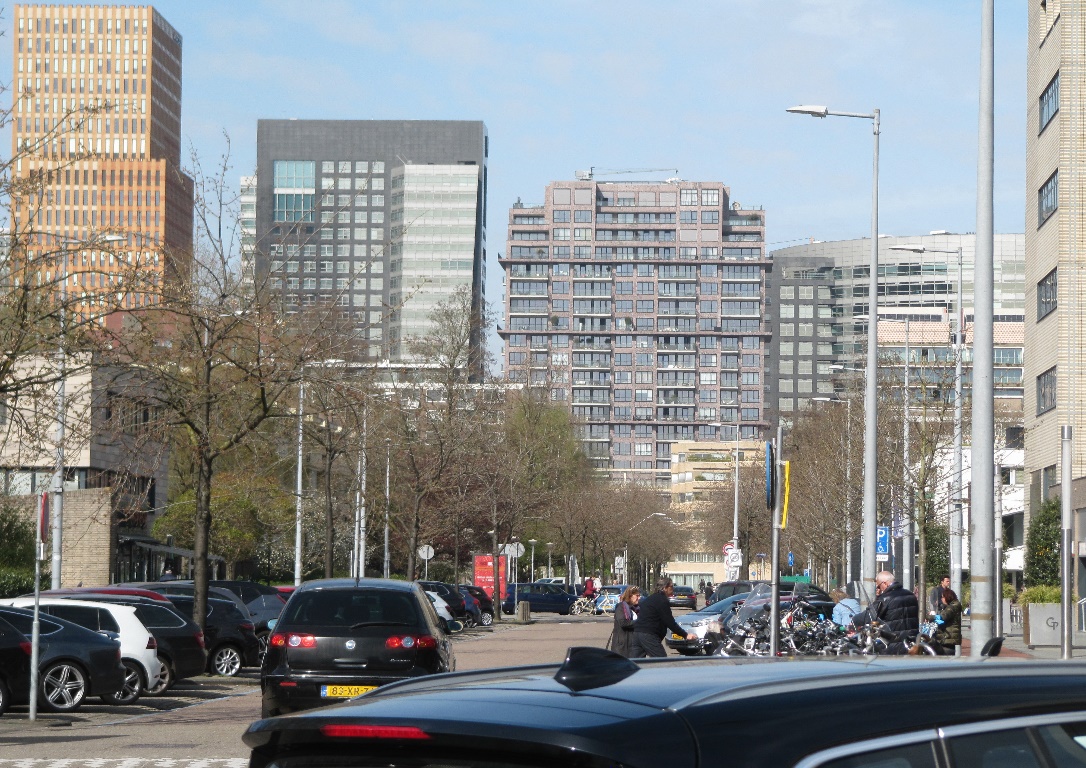 View at Zuidas from Willem van Weldammelaan (March 2022)